Central Valley Earthquake Hazards
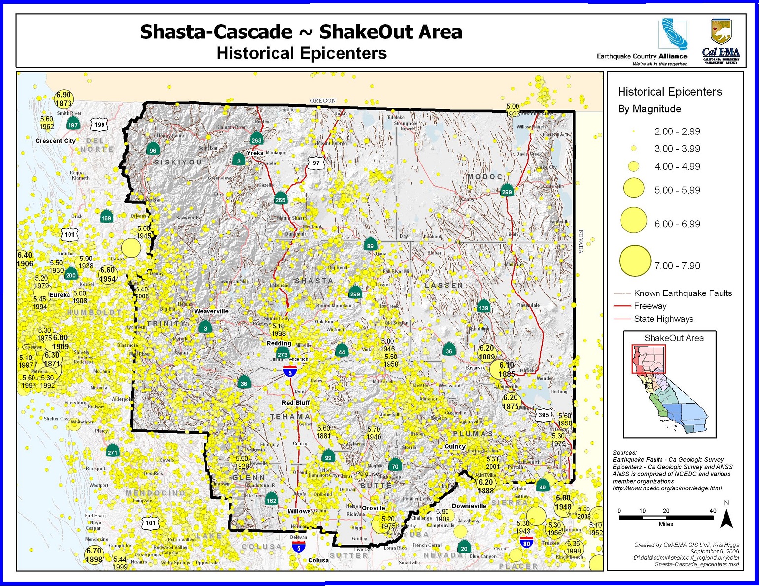
Those who are lucky enough to live in the northernmost part of the state enjoy spectacular scenery and remote vistas. The Trinity Mountains, Modoc Plateau, Shasta and Lassen peaks show how the forces that created them are still shaping the landscape today. But no matter where you live in the Northern and Northeastern parts of the state, you live in earthquake country. Understanding the risks and preparing to survive and recover can help keep you and your family safe. The Shasta Cascade area may seem remote from the well-known faults in the state such as the San Andreas. It may be a surprise that almost everyone in the region lives within 20 miles of an active fault. The Modoc plateau is a region of both active volcanism and faulting and much of the northeastern part of the state is being stretched apart by basin and range faults. Residents could also be affected by very large earthquakes further away and closer to the coast. It doesn’t take much shaking to trigger landslides that can quickly block roads and highways, isolating the region.
|
|

Oroville Dam/Risk of Collapse
Oroville Dam is an earthfill embankment dam on the Feather River east of the city of Oroville, California, in the Sierra Nevada foothills east of the Sacramento Valley. At 770 feet (235 m) high, it is the tallest dam in the U.S.[8] and serves mainly for water supply, hydroelectricity generation and flood control. The dam impounds Lake Oroville, the second largest man-made lake in the state of California, capable of storing more than 3.5 million acre feet (1.1 trillion US gallons; 4.3 trillion litres).[9]
Built by the California Department of Water Resources (DWR), Oroville Dam is one of the key features of the California State Water Project (SWP), one of two major projects passed that set up California's statewide water system. Construction was initiated in 1961, and despite numerous difficulties encountered during its construction, including multiple floods and a major train wreck on the rail line used to transport materials to the dam site, the embankment was topped out in 1967 and the entire project was ready for use in 1968. The dam began to generate electricity shortly afterwards with completion of the Edward Hyatt Pump-Generating Plant, then the country's largest underground power station.
Since its completion in 1968, the Oroville Dam has allocated the flow of the Feather River from the Sacramento-San Joaquin Delta into the State Water Project's California Aqueduct, which provides a major supply of water for irrigation in the San Joaquin Valley as well as municipal and industrial water supplies to coastal Southern California, and has prevented large amounts of flood damage to the area—more than $1.3 billion between the years of 1987 and 1999.[10] The dam stops fish migration up the Feather River and the controlled flow of the river as a result of the Oroville Dam has affected riparian habitat. Multiple attempts at trying to counter the dam's impacts on fish migration have included the construction of a salmon/steelhead fish hatchery on the river, which began shortly after the dam was completed.
In February 2017, the main and emergency spillways threatened to fail, leading to the evacuation of 188,000 people living near the dam.[11] After deterioration of the main spillway largely stabilized[12] and the water level of the dam's reservoir dropped below the top of the emergency spillway, the evacuation order was lifted.[13]
The San Andreas Fault is a continental transform fault that extends roughly 1,200 kilometers (750 mi) through California.[1] It forms the tectonic boundary between the Pacific Plate and the North American Plate, and its motion is right-lateral strike-slip (horizontal). The fault divides into three segments, each with different characteristics and a different degree of earthquake risk. The slip rate along the fault ranges from 20 to 35 mm (0.79 to 1.38 in)/yr.[1]
The fault was identified in 1895 by Professor Andrew Lawson of UC Berkeley, who discovered the northern zone. It is often described as having been named after San Andreas Lake, a small body of water that was formed in a valley between the two plates. However, according to some of his reports from 1895 and 1908, Lawson actually named it after the surrounding San Andreas Valley.[2] Following the 1906 San Francisco earthquake, Lawson concluded that the fault extended all the way into southern California.
In 1953, geologist Thomas Dibblee concluded that hundreds of miles of lateral movement could occur along the fault. A project called the San Andreas Fault Observatory at Depth (SAFOD) near Parkfield, Monterey County, was drilled through the fault during 2004–2007 to collect material and make physical and chemical observations to better understand fault behavior.[3]
|
|

Lassen Volcanic National Park
All four types of volcanoes found in the entire world are represented in Lassen Volcanic National Park— shield (Prospect Peak), plug dome (Lassen Peak), Cinder Cone (Cinder Cone), and Composite (Brokeoff Volcano) volcanoes.In August of 1916, Lassen Volcanic National Park was established. The park and Lassen Peak take their name from Peter Lassen, one of the first white settlers in the northern Sacramento Valley, who discovered of a route through the mountains called the Lassen Trail.
To see these volcanic sites, Lassen Volcanic National Park offers both summer and winter weather activities. With over 150 miles of hiking trails, both day hiking and backpacking are popular summer activities. Winter conditions often begin as early as October and persist through June or July making snow play, snowshoeing, and backcountry skiing great options for cold months.
|
|