Sutter County Board Of Supervisors

1160 Civic Center Blvd # A
Yuba City, CA 95993
(530) 822-7106
(530) 822-7103

Press On Image To Enlarge
Calfornia State Homepage

Yuba-Sutter Chamber of Commerce

Janell Willis Executive Director
1300 Franklin Rd
Yuba City, CA 95993
(530) 743-6501

City of Yuba
Sutter County

Demographics

County Demographics
State Wide Emergency Resources
Updated 7/6/2024

I Primary Emergency Providers


Sutter County Sheriff Office

Sheriff Brandon Barnes
1077 Civic Center Blvd
Yuba City, CA 95993
(530) 822-7307

Sutter County Emergency Services

Steven Smith Director County Administrator
Zachary Hamill Operations Manager
1130 Civic Center Boulevard, Suite E
Yuba City, CA 95993
(530) 822-4575
Fax Number:(530) 822-7724

Sutter County Sheriff Communications Unit

Lopez, Tabatha Communications Manager PSAP
1077 Civic Center Blvd
Yuba City, CA 95993
(530) 822-7307

II Hospitals & Fire Departments


Sutter Surgical Hospital North Valley

455 Plumas Blvd
Yuba City, CA 95991
(530) 749-5700

Sutter County Fire Services
Fire Chief John Shalowitz Yuba City, CA 95993
(530) 822-4575
Fax Number:(530) 822-7724
Directory of All California Fire Departments
1. Directory Access 2023 Published By California State

2. Directory 1 Solano County Fire Department

3. Directory 2 Fire DepartmentsIn Sonoma County

Yuba City Fire Department

Jesse Alexander, Fire Chief
Ali Williams, Division Chief of Operations
Josh Hubbard, Division Chief- Training/ Risk Reduction
824 Clark Ave,
Yuba City, CA 95991
530) 822-4686

Ambulance Service Bi-County

1700 Poole Blvd
Yuba City, CA 95993
(530) 674-2780

Press On Image to Enlarge

Radio Reference Online

Press On Image To Enlarge

The Yuba-Sutter Amateur Radio Club
President: Chris McLain (KK6VZD)
146.085 pl tone of 127.3 with a positive offset.

III Service Providers In Sutter County


Amerian Red Cross
Northern California Chapter
Christine Woods Emergency Management
2125 E W Onstott Frontage Rd
Yuba City, CA 95991
(530) 673-1460

Yuba-Sutter-Colusa United Way

Executive Director - Robert Harlan
300 4th S
Marysville, CA 95901
Phone: (530) 743-1847

Hands of Hope Family Homeless Shelter

Rick Millhollin Executive Director
909 Spiva Avenue,
Yuba City, CA 95991
(530) 755-3491

Salvation Army Yuba Corp

Julius & Shannon Murphy:
401 Del Norte Ave
Yuba City, CA 95991
(530) 216-4530

Sutter County Health and Human Services

Sarah Eberhardt-Rios HHS Director
545-B Garden Highway
Yuba City, CA 95991
(530) 822-7327 ext. 202

Sutter County Public Health

1445 Veterans Memorial Cir
Yuba City, CA 95993
(530) 822-7215

IV Sutter County and Yuba City


Sutter County Board Of Supervisors

1160 Civic Center Blvd # A
Yuba City, CA 95993
(530) 822-7106
(530) 822-7103

Yuba City

Mayor Wade Kirchner
and City Council
1201 Civic Center Boulevard,
Yuba City, CA 95993
(530) 822-4602

City of Live Oak

Mayor Bob Woten
and City Council
9955 Live Oak Blvd
Yuba City, CA 95993
(530) 695-2122

V Public Utilities & Vital Resources


PG&E, Pacific Gas and Electric

Press On Image State Power Grid
P.O. Box 997300
Sacramento, CA 95899-7300
24-hour Power Outage Information Center
1-800-743-5002

California Department of Education

Press On Image Directory School Districts
1430 N Street
Sacramento, CA 95814-5901
General: 916-319-0800

California Department of Health

Press On Image Directory Public Hospitals
PO Box 997377, MS 0500
Sacramento, CA 95899-7377
(916) 558-1784

California Department of Transportation

Press On Image Raillines
1120 N Street
Sacramento, CA 95814
General Information:
(916) 654-2852

California Highway Patrol

Commissioner Sean Duryee
601 N 7th St,
Sacramento, CA 95811
916) 843-3000

VI Radio and Television Stations


News 10 ABC KXTV

Gannett KXTV Digital Full-Power - 34.5 kW
400 Broadway
Sacramento, CA 95818-2098
Tel: (916) 441-2345
Fax: (916) 321-3384

KCRA 3 NBC

Hearst Television Digital Full-Power - 1000 kW
Email
3 Television Circle
Sacramento, CA 95814-0794
916-446-3333
916-444-7316

CBS 13 KOVR

CBS Corporation KOVR Digital Full-Power - 760 kW
Email
2713 KOVR Drive,
West Sacramento, CA 9560
NEWS TIPS: Call (916) 374-1301
toll-free: 1 (800) 374-8813

KUBA
Greatest Hits Rock and Roll
Chris Rey Operations Manager
1479 Sanborn Dr.
Yuba City CA 95993
Office 530-673-2200
Fax 530-673-3010


KFBK
News Talk
1545 River Park Drive, Ste. 500
Sacramento, CA 95815
Business Line: 916-929-5325
Newsroom Line: 916-924-3901


KSEG The Eagle 96.9
Classic Rock
5345 Madison Ave
Sacramento, California, 95841
916) 334-7777

Press On Image To Enlarge

Radio Locator Com

Press On Image To Enlarge

Sutter County Airport
Neal Hays Manager
130 Civic Center Blvd
Yuba City, CA 95993
Phone (530) 822-7400

Yuba Sutter Transit
Keith Martin, Executive Director
2100 B Street,
Marysville, CA 95901
(530) 634-6880

Appeal Democrat Newspaper
Newsroom
1530 Ellis Lake Drive
Marysville, CA 95901
Phone: 530- 749-4700

VII Central Valley Earthquake Hazards

Oroville Dam/Risk of Collapse
Natural Flood Plain-Major Risk Flooding

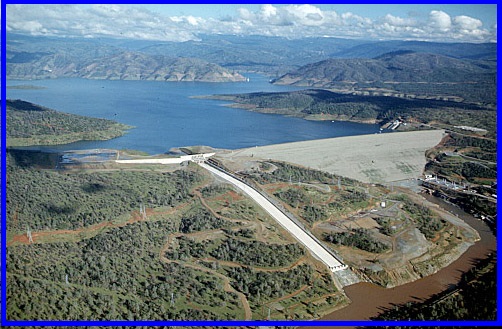
Oroville Dam is an earthfill embankment dam on the Feather River east of the city of Oroville, California, in the Sierra Nevada foothills east of the Sacramento Valley. At 770 feet (235 m) high, it is the tallest dam in the U.S.[8] and serves mainly for water supply, hydroelectricity generation and flood control. The dam impounds Lake Oroville, the second largest man-made lake in the state of California, capable of storing more than 3.5 million acre feet (1.1 trillion US gallons; 4.3 trillion litres).[9]

Built by the California Department of Water Resources (DWR), Oroville Dam is one of the key features of the California State Water Project (SWP), one of two major projects passed that set up California's statewide water system. Construction was initiated in 1961, and despite numerous difficulties encountered during its construction, including multiple floods and a major train wreck on the rail line used to transport materials to the dam site, the embankment was topped out in 1967 and the entire project was ready for use in 1968. The dam began to generate electricity shortly afterwards with completion of the Edward Hyatt Pump-Generating Plant, then the country's largest underground power station.

Since its completion in 1968, the Oroville Dam has allocated the flow of the Feather River from the Sacramento-San Joaquin Delta into the State Water Project's California Aqueduct, which provides a major supply of water for irrigation in the San Joaquin Valley as well as municipal and industrial water supplies to coastal Southern California, and has prevented large amounts of flood damage to the area—more than $1.3 billion between the years of 1987 and 1999.[10] The dam stops fish migration up the Feather River and the controlled flow of the river as a result of the Oroville Dam has affected riparian habitat. Multiple attempts at trying to counter the dam's impacts on fish migration have included the construction of a salmon/steelhead fish hatchery on the river, which began shortly after the dam was completed.

Oroville Dam/Risk of Collapse
Natural Flood Plain-Major Risk Flooding


In February 2017, the main and emergency spillways threatened to fail, leading to the evacuation of 188,000 people living near the dam.[11] After deterioration of the main spillway largely stabilized[12] and the water level of the dam's reservoir dropped below the top of the emergency spillway, the evacuation order was lifted.[13] The San Andreas Fault is a continental transform fault that extends roughly 1,200 kilometers (750 mi) through California.[1] It forms the tectonic boundary between the Pacific Plate and the North American Plate, and its motion is right-lateral strike-slip (horizontal). The fault divides into three segments, each with different characteristics and a different degree of earthquake risk. The slip rate along the fault ranges from 20 to 35 mm (0.79 to 1.38 in)/yr.[1]

The fault was identified in 1895 by Professor Andrew Lawson of UC Berkeley, who discovered the northern zone. It is often described as having been named after San Andreas Lake, a small body of water that was formed in a valley between the two plates. However, according to some of his reports from 1895 and 1908, Lawson actually named it after the surrounding San Andreas Valley.[2] Following the 1906 San Francisco earthquake, Lawson concluded that the fault extended all the way into southern California.

In 1953, geologist Thomas Dibblee concluded that hundreds of miles of lateral movement could occur along the fault. A project called the San Andreas Fault Observatory at Depth (SAFOD) near Parkfield, Monterey County, was drilled through the fault during 2004–2007 to collect material and make physical and chemical observations to better understand fault behavior.[3]

IX Maps of Sutter County Yuba City


Press On Image To Enlarge

Yuba City Map

Press On Image To Enlarge

Sutter County Flood Zone Map

Press On Image To Enlarge

Sutter County Earthquake Zone Map

Press On Image to Enlarge

Sutter County Map

Press On Image To Enlarge

Sutter County Map

Press On Image To Enlarge

Sutter County Wildfire Zone Map