Elementary School
Bessey Creek Elementary
2201 S.W. Matheson Avenue,
Palm City, Florida 24990
(772) 219-1500
Crystal Lake Elementary
2095 S.W. 96th Street
Stuart, Fl 34997
772-219-1525
Fax: 772-219-1529
Felix A. Williams Elementary
401 NW Baker Rd.
Stuart, Florida  34994
772) 219-1640
Fax: (772) 219-1646
Hobe Sound Elementary
11555 S.E. Gomez Avenue,
Hobe Sound, FL 33455
772) 219-1540
Jensen Beach Elementary
J.D. Parker School
1050 East 10th Street
Stuart, Florida 34996
(772) 219-1580
FAX: (772) 219-1583
Palm City Elementary
1951 SW 34th Street
Palm City,Fl 34990-3235
Pinewood Elementary
5200 S.E. Willoughby Blvd
Stuart, Fl 34997
772) 219-1595
Port Salerno Elementary
4890 SE Jack Ave.
Port Salerno, FL  34997
(772) 219-1610
Seawind Elementary
3700 SE Seabranch Blvd.
Hobe Sound, Fl  33455
772-219-1625
Warfield Elementary
15261 SW 150th St.
Indiantown, Florida   34956
772-597-2551
Fax:772-597-2119
Middle School
Hidden Oaks Middle
2801 S.W. Martin Hywy,
Palm City, Florida, 33490
772-219-1655,
Fax 772-219-1663
Indiantown Middle
16303 SW Farm Road
Indiantown, FL 34956
772) 597-2146
Fax:  (772) 597-5854
Murray Middle
4400 S. E. Murray Street
Stuart. Fl 34997
772-219-1670
Stuart Middle
High School
Martin County High School
2801 S. Kanner Hwy.
Stuart, FL 34994
(772)-219-1800
South Fork High School
10205 SW Pratt & Whitney Rd.
Stuart, FL 34997
772-219-1840
Fax 772-219-1860
Fire and Recue
Fire Chief: Larry Massing
EMS Division Chief: Lori Recca
800 Martin Luther King Jr. Blvd.,
Stuart, Fl.  34994
Station # 2
1100 E. Monterey Road Extension,
Stuart, Fl. 34994
772-288-5360
Fax: 772-288-5371

Stuart Police Department
Chief Edward M. Morley
830 SE Martin Luther King Jr
Stuart, Fl 34994
(772) 287-1122
Dispatch
(772) 287-1122 Ext. 1
Records
(772) 287-1122 Ext. 2
Administration
(772) 287-1122 Ext. 4
Other Cities
1.	Port Salerno
	Port Salerno Fire Station
	4725 SE Dixie Hwy,
	Stuart, FL
	(772) 287-8713
|
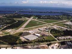
Whitman Field Airport KSUA
By Air Nav.Com
FAA Identifier:KSUA
Lat/Long:
27-10-54.1000N / 080-13-15.9000W
27-10.901667N / 080-13.265000W
27.1816944 / -80.2210833
(estimated)
Elevation:
18 ft. / 5.5 m (surveyed)
Variation:  05W (2000)
From city:
1 mile SE of STUART, FL
Zip code:  34996
Airport Operations
Airport use:  Open to the public
Sectional chart:  MIAMI
Control tower:  yes
ARTCC:  MIAMI CENTER
FSS:
Miami Flight
Service Station
[1-866-347-0316]
NOTAMs facility:
MIA (NOTAM-D service available)
Attendance:  0700-2000
Wind indicator:  lighted
Segmented circle:  no
Lights:  DUSK-DAWN
MIRL RYS 12/30 & 07/25
PRESET MED INTST DUSK-2300.
ACTVT REIL RYS 12 & 30 AND AFTER 2300,
ACTVT MIRL RYS 12/30 & 07/25 - CTAF.
PAPI RYS 12, 30, 07, & 25 OPER CONT.
Beacon:
white-green (lighted land airport)
Airport Communications
CTAF:  126.6
ATIS:  134.475
WX AWOS-3:
PHONE 772-781-1642
STUART GROUND:
121.7 [0700-2000]
STUART TOWER:
126.6 [0700-2000]
Palm Beach Approach 128.3
Palm Beach Departure 128.3
EMERG:  121.5 243.0
FLIGHT TEST:  123.4 275.2
Nearby radio navigation aids
VOR radial/distance
VOR name    Freq    Var
PBIr350/30.9
Palm Beach Vortac  115.70  03W
VRBr158/33.1
Vero Beach Vortac  117.30  04W
PHKr046/34.7
PAHOKEE VORTAC  115.40  00E
NDB name
Hdg/Dist    Freq    Var    ID
FORT PIERCE
160/20.0  275  04W  FPR
Vero Beach
164/30.8  392  04W  VEP
Airport Services
Fuel available:  100LL JET-A
Parking:  tiedowns
Airframe service:  MAJOR
Powerplant service:  MAJOR
Bottled oxygen:  NONE
Bulk oxygen:  NONE


Runway 12/30


Dimensions:
5826 x 100 ft. / 1776 x 30 m
Surface:
asphalt/grooved, in good condition
Weight limitations:
Single wheel:  65000 lbs
Double wheel:  105000 lbs
Double tandem:  190000 lbs
Runway edge lights:  medium intensity
Latitude:
27-10.917667N  27-10.584500N
Longitude:
080-13.887000W  080-12.878333W
Elevation:  15.7 ft.  13.8 ft.
Traffic pattern:  left  left
Runway heading:
115 magnetic, 110 true
295 magnetic, 290 true
Displaced threshold:  660 ft.  460 ft.
Markings:
nonprecision, in good condition
Visual slope indicator:
4-light PAPI on left
(3.00 degrees glide path)
4-light PAPI on left
(3.00 degrees glide path)
Runway end identifier lights:  yes  yes
Obstructions:
50 ft. trees, 600 ft.
from runway, 8:1 slope to clear
APCH SLOPE 21:1 TO DSPLCD THLD.
37 ft. trees, 570 ft. from runway,
10:1 slope to clear
APCH SLOPE 27:1 TO DSPLCD THLD.


Runway 16/34


Dimensions:
5000 x 100 ft. / 1524 x 30 m
Surface:
asphalt, in fair condition
Weight limitations:
Single wheel:  55000 lbs
Double wheel:  90000 lbs
Double tandem:  160000 lbs
Latitude:
27-11.310833N  27-10.566667N
Longitude:
080-13.298500W  080-12.899500W
Elevation:  13.8 ft.  13.5 ft.
Traffic pattern:  left  left
Runway heading:
159 magnetic, 154 true
339 magnetic, 334 true
Displaced threshold:  335 ft.  880 ft.
Markings:  basic, in good condition
Obstructions:
none  35 ft. trees,
870 ft. from runway,
19:1 slope to clear
APCH RATIO 50:1 TO DSPLCD THLD.


Runway 7/25


Dimensions:
4652 x 100 ft. / 1418 x 30 m
Surface:
asphalt, in fair condition
Weight limitations:
Single wheel:  58000 lbs
Double wheel:  95000 lbs
Double tandem:  170000 lbs
Runway edge lights:  medium intensity
Latitude:
27-10.900667N  27-11.184333N
Longitude:
080-13.741000W  080-12.943000W
Elevation:  16.7 ft.  11.5 ft.
Traffic pattern:  left  left
Runway heading:
073 magnetic, 068 true
253 magnetic, 248 true
Displaced threshold:  no  400 ft.
Markings:  basic, in good condition
Visual slope indicator:
2-light PAPI on left
2-light PAPI on left
Obstructions:
none  70 ft. trees,
1400 ft. from runway,
17:1 slope to clear
APCH SLOPE 25:1 TO DSPLCD THLD.
|


